Trails
Hiking and cross-country ski trails are available at the Mines of Spain. Check with the park manager for cross-country ski routes, from the interpretive center to the south end of the recreation area. Six miles trails groomed for cross country skiing when snow permits and 21 miles of maintained hiking trails. There are six individual nature walks within the park, including those at the E.B. Lyons Interpretive Center and another at the Horseshoe Bluff Site. Other trails provide a wide range of opportunities for visitors to view Mines of Spain on old winding logging roads, to view limestone bluffs, scenic overlooks, and to enjoy a hike through forests and prairie. Some of the trails are steep and challenging. Dogs on 6 foot leashes are allowed. No bikes allowed.
MINES OF SPAIN TRAIL MAP CLICK HERE
There are no camping facilities available at the Mines of Spain
The Trails
Trails note- Trails in the Mines of Spain can be affected by water depths of the Mississippi River. Catfish Creek which runs through the park consists of back waters of the river and its depth varies with the rivers depth. Please check water depths of the river by going to River Gages Website Flood stage in Dubuque is 17 feet. The portions of the Calcite Trail and Mesquakie Trail are affected when the river stage is at 15 feet. The Catfish Creek Trail will be affected when the depth rises to 18 feet. Flooding of the trails usually occurs in May. Please check the Corp of Engineers flood data or call the park office for updates.
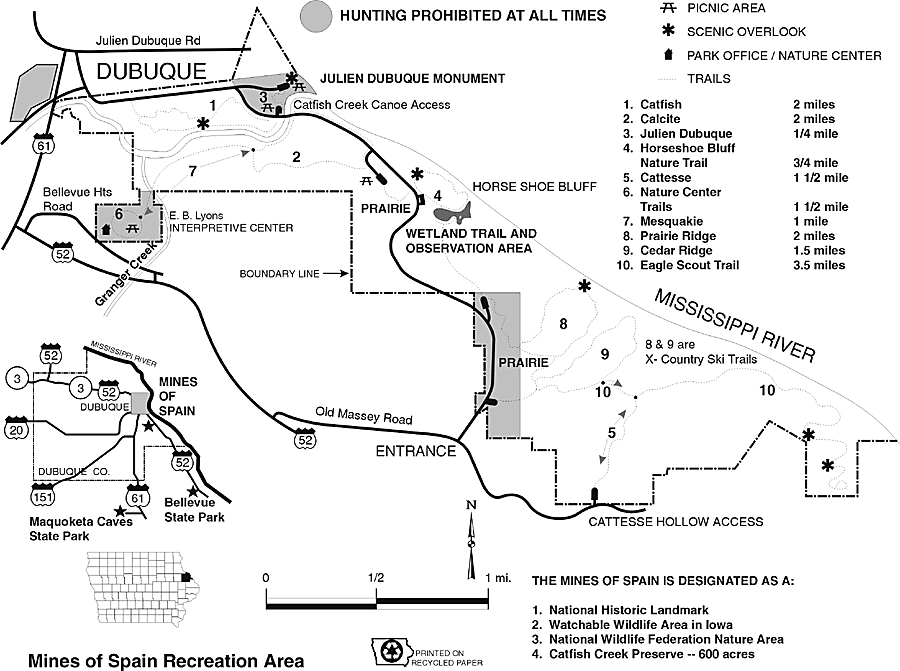
1. Catfish – 2 miles: This trail covers a wide range of area. The lower portions find its way along Catfish Creek which gives the trail its name. The upper portion goes past rock out-croppings, through white Birch and River Birch forested areas. A savanna area on the east end includes Indian Mounds and 200+-year-old Oak trees.
2. Calcite – 2 miles: This trail is named for the common rock found in the park, Calcite. A large sample is at the trailhead in the parks main picnic area. While on the trail watch for bowl shaped holes in the ground – lead mine pits. This trail is steep at the start by the main picnic area.
3. Julien Dubuque – .25 mile With access from the parking lot, this level sidewalk trail leads to Julien Dubuque’s Monument which is a National Historic Landmark. This handicap accessible area features a scenic river overlook and benches and picnic tables.
Julien Dubuque Foot Trail – The trail starts at the Monument and winds down to the north into Riprow Valley. The trail dead ends in Riprow Valley near the Mississippi River. Julien Dubuque Foot Trail South is about .5 mile in length that goes down to the Canoe Launch Parking lot at Catfish Creek.
4. Horseshoe Bluff Nature Trail – ¾ miles Accessible from the main park road, this trail features a scenic overlook at the north end. From here you can see the Julien Dubuque monument to the north and view the old quarry to the south with the Mississippi River in the background. Interpretive signs explain the parks geological history. You can also enter the quarry from the south going past the wetland. There are steps along the Eastern edge and trail ramp to the West.
5. Cattesse – 1 ½ miles: The trail means Catfish-East Southeast. The trail starts flat and goes up through a major valley cutting the park in half. Spring, fall and winter allow you to see and explore the rock out croppings, some 70 feet high. In the summer the trail has dense foliage prohibiting you from seeing the rocks.Eagle Scout trail extends off of this trail to the south.
6. Nature Center Trails – 1 ½ miles. Trails lead from the E.B. Lyons Interpretive Center. Junkerman-Pine Chapel Trail includes remnants of an 1859 farm area including: a hillside lane, meadow, farm garden area, natural prairie, pine chapel, grapevine terraces, farm site, root cellar, chimney rock and creek overlook, wine cellar, meadow trail, bridge, table bluff, surface lead mine, shaft lead mine, and ravine.
7. John and Alice Butler Trail- .5 mile – This ADA paved trail is near the EB Lyons Interpretive Center. This paved trail meanders through restored prairie where you can view native birds and prairie plants. Trail ends with a large compass interpretive area that is paved for group settings. Interpretive signage. America’s State Tree Woodland Walk spurs off of this trail. Nearby paved parking and bus parking available.
8. America’s State Tree Woodland Walk Spur Trail – .3 mile -This mowed path has examples and signage of America’s State Trees. See trees in clusters along this trail. This trail spurs off of the John and Alice Butler Trail. Interpretive signage. Nearby paved parking and bus parking available.
9. Mesquakie Trail – 1 mile: This trail connects the E.B. Lyons Center with the rest of the Mines of Spain. Access is from the northeast corner of the Nature Center Trails. This trail will take you across Granger Creek and along Catfish Creek on its south side. It will eventually hook-up with the Calcite Trail.
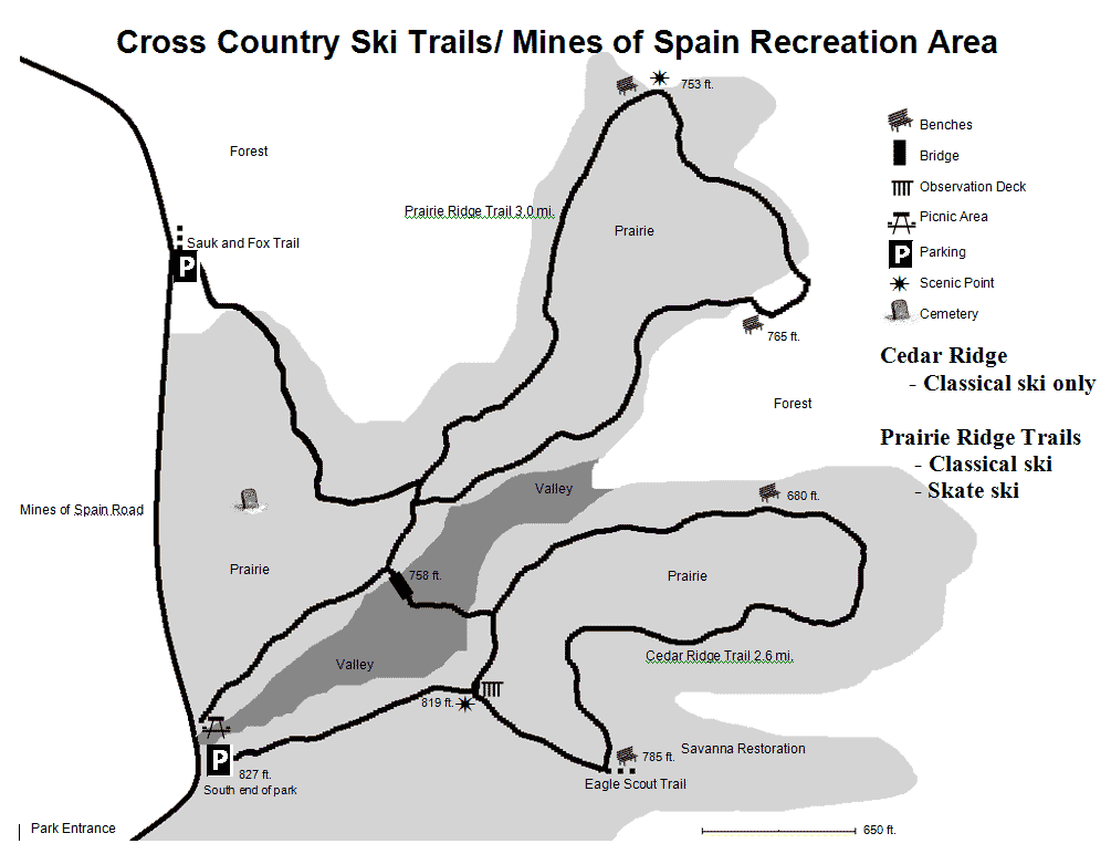
10. Prairie Ridge Trail – 2 miles: This trail has been designed for cross-country skiing and for hiking. The trail passes through tall grass prairie that has been planted in sections from 1994 to 2001.
11. Cedar Ridge Trail- 1 ½ miles: This trail has been designed for cross-country skiing and hiking. The trail passes through areas that were planted with Red Cedar trees during the 1980’s.
12. Eagle Scout Trail – 3 ½ miles. This trail starts at an intersection on the Cedar Ridge Trail. It winds down and connects with the Cattesse trail where it continues to the extreme south end of the park. The trail has been built by Boy Scouts earning their Eagle Scout award. This trail is long, winding through forests, prairie and cropland. You probably will not see other hikers, as this is a remote area in the south end of the park.
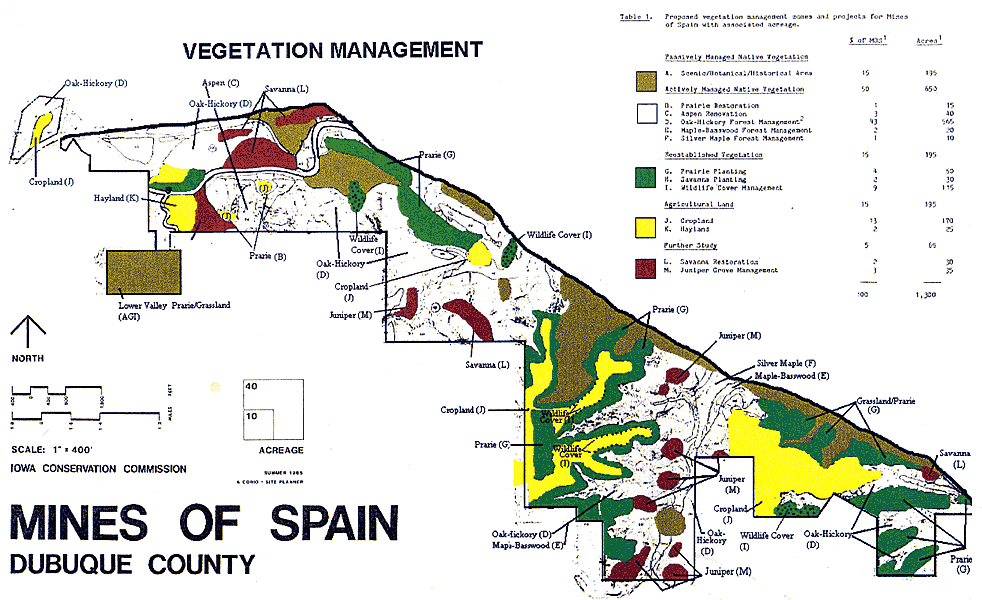
Vegetation at the Mines of Spain – PDF listing of vegitation here
Wildlife of the Mines of Spain – PDF listing of what can be found here
Bird Checklist – PDF of the birds you may see on your visit
Downloadable Maps
EB Lyons Interpretive Center Google Map & Directions
MINES OF SPAIN TRAIL MAP CLICK HERE
Color Mines Guide & Trail Map (228K PDF)
Color Mines Guide & Trail Map (238K JPG)
Cross Country Ski Trails (90K PDF)
Cross Country Ski Trails (32K GIF)
Mines Guide & Trail Map (64K GIF)
Vegetation Management Map (85K GIF)
Aerial Map of the park (90K JPG)
Driving Directions:
EB Lyons Interpretive Center
8991 Bellevue Heights
Dubuque, IA 52003-9214
From Illinois:
Hwy US-20 West from Illinois to Dubuque, Iowa across bridge
At base of bridge(stoplight) turn Left onto Hwy US-61 South
Go approximately 1.7 miles to Stoplight at US-52
Left onto US-52
Immediately turn left onto Bellevue Heights
Follow road and EB Lyons parking is on the left
From Wisconsin:
Hwy US-61 to Dubuque, Iowa across bridge
Continue on US-61 and up the hill
Go Left onto US-52 at stoplight by Hardies
Immediately turn left onto Bellevue Heights by Banwarth & Udelhoven Furniture
Follow road and EB Lyons parking is on the left
From Dubuque Downtown:
US-61Continue on US-61 and up the hill
Go Left onto US-52 at stoplight by Hardies
Immediately turn left onto Bellevue Heights by Banwarth & Udelhoven Furniture
Follow road and EB Lyons parking is on the left
Google Maps Link to Julien Dubuque Monument
Friends of The Mines of Spain, Dubuque, IA 52003-9214, 563-556-0620